Tag Archives: #rain

The Home Stretch

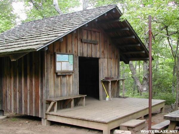
Around 4PM, I began my climb out of Dick’s Creek Gap toward the top of Powell Mountain, fully stocked on snacks again (and sporting a brand new pair of Leki pokes), but all alone. After 3.5 miles, I stopped at Deep Gap Shelter to check it out. It was one of those shelters designed like an outdoor theater, with a wide stage on the front. I took off my shoes to let them air out and started on my snacks. I was listening to the new audiobook I had downloaded on Mama’s laptop at the Unicoi Lodge: Cory Doctorow’s For the Win. I wasn’t exactly expecting a YA novel, but I was getting into it a bit, just on the basis of the unusually multicurtural characters. Actually, I can’t remember another time I’ve read any other novel not largely focused on American characters. Oh, I remember one: Neal Stephenson’s The Diamond Age. I’m getting off-track. So, yeah, I sat there on the bench on the front of the shelter for the brighter part of the afternoon before I finally decided to get going.

by Youngblood on whiteblaze.net

by Youngblood on whiteblaze.net

Continue reading

If ya can’t beat ’em, Gorham to Pinkham

…And we’re back!

After about 2 weeks, I’d managed to complete about 70 miles of the “real” Whites. That averages to about five miles per day. Even two months before, when I’d spent half of every day swimming in lakes, I was averaging better than that. And I still had 45 left to go before the Maine border. And I can tell you now: my average didn’t improve much at all for the remainder of it. When it comes to arduous hiking, there’s nothing like the Whites anywhere on the eastern seaboard.

I had set myself up on the edge of the road and the parking lot so I could try to bum rides from hikers leaving or entering the woods. It didn’t take super long to find a couple in a van headed towards Gorham on the way out of state and home. They took me to Gorham, and I explained that actually I was trying to get to the Lodge just on the eastern end of town near the A.T. They were perfectly happy to carry me that far, even though it was well out of their way.

Eventually (eons later), an older couple in a van picked me up, indicating that they were hikers themselves and very amenable to giving them a lift when they get the chance. They drove me right to the doorstep of the Lodge, even though it was much farther than I expected, way past the far end of town.

Continue reading

Things are looking up, but I’m slowing down, and Copper’s right out

A nasty bout of weather cut short my one-week-to-Pinkham-Notch plan after a mere 5 days. Six days after being shuttled from Chet’s out to Kinsman Notch, I was back again. And I wasn’t the only one. Icarus was back again, having spent the past few days hiking the Pemi with Damselfly and Splash. He showed me pictures they took cavorting on the edge of Bondcliff and enjoined me to go see it myself, extolling it as the most beautiful spot in the Whites, and judging from the pictures, it seemed likely he wasn’t exaggerating.

1265415_10151859650750033_2100647129_o

An epic battle for Bondcliff (by Rachel “Damselfly” Kirchoefner, with Chris Eli “Icarus” Polett and Josh “Splash” Isbell)

Continue reading

Beeline for the Treeline

I was one of the first out of bed that morning at Hikers Welcome Hostel. I was in the lounge before the pancakes were. I ate as much of what looked good as I could get my hands on, and made sure my slackpack was packed and the rest of my gear squared away to catch the first shuttle to the other side of Moosilauke.

The weather was actually pretty good for climbing a four-thousand footer that morning. There was fog and cloud early on, but it was clear by the time Copper and I hit the trail and started climbing. It stayed cloudy all day, but it didn’t rain until the afternoon, and was just gorgeous through the hiking part of the day.

The AT runs right past a parking lot at Kinsman Notch, so Copper was already on the trail before I had gotten out of the car and put my fanny pack (which detaches from my pack) on. He was trying to go north though. I called him back, and soon we were walking alongside the Beaver Brook.

Moosilauke doesn’t play around. Going southbound, you start climbing almost immediately, and the trail literally climbs the edge of the waterfalls, perhaps somewhat like the Panther Creek Falls Trail in North Georgia, only steeper and more popular.

image

Continue reading

Cruisin’…Slowly

Derecho’s effects were meant to be felt most strongly in the following afternoon, so I decided I would try to get a taxi to the post office and back to the trailhead the following morning, which meant I needed to get some resupply that night. There was a Save-A-Lot down the street from Gus and Ted’s, but it was quite a trek by the time I delivered the hot wings back to the room and fed Copper. In fact, after I walked the mile back there, it had closed, and so had the adjacent laundromat, so there was no possibility of washing clothes that night with real detergent. I took a different street back to the hotel, and managed to pass a Turkey Hill, a convenience store owned by Kroger and stocked with a small selection of Kroger brand foods. So I added some dinners and snacks and grabbed a gallon of green tea to eat with my hot wings and went home to wash my clothes with Softsoap in the bathtub. I never felt like eating dinner; the hot wings went untouched.
The next morning, I walked to the breakfast nook in a brooding cloud, and by the time I got my waffle and bagel and cereal made, it had started thundering. I took the food back to the room to give Copper some comfort from the thunder, but he seemed fine. After breakfast, I called the post office. They said they hadn’t gotten my package from Steph yet. I cursed a bit and went down to the lobby to drop another 80 bucks. The storm stopped within an hour and no more of Derecho’s cells came through that day, so the US Postal Service was entirely responsible for my taking a zero.

Continue reading

More Rain, More Rocks, Out of Maryland

April Johanssen, a 35-year-old single mom, is turning her life around by getting back to nature. After years of rarely leaving her house in Chicago, she became obsessed with Harper’s Ferry and drew on the support of local and online communities to fund a break-out camping and hiking trip. It’s almost a week into that trip now, and her funds, those she didn’t spend on food and gear, are running low. So, she starts volunteering in exchange for her site at the hostel, and, because she’s got to work four hours a day, she’s not getting to much of the hiking she came to do. The debilitating migraines don’t help either. And when she does have time to hike, after all that work is done, for one reason or another, she just doesn’t feel like it. She’s not getting done the thing she came to do. She wants to try a longer trip with the backpack, but her tent is too big to carry, and she’s never even done a day hike with the pack on. She needs some practice, and a push.
So she had to climb up Weverton Cliffs with me. It’s only a couple of miles, after all, and I need someone to take my picture in front of that gorgeous view anyway.

Continue reading

Neros on the Rocks with a Splash of Water

When I last posted, Copper had just completed his first supravigintal day, and I was tented on a cant on a tangle of shrubs just out of the wind. I woke up late the next morning, of course, having been up until 2am, and by the time I packed up the next morning, all of the folks I’d left 8 mi. back at Niday Shelter had passed me. It would seem that my extra walking in the night hadn’t bought me anything, but the truth is, I can’t imagine getting up early enough to walk 18 miles by 4:30pm, but I only had ten miles to go on fresh legs.
Halfway down the hill I was stopped by a random guy who was interviewing everyone that came down that hill, collecting trail names, hometowns, start points, etc. for some video blog thing. I was still too sleepy to remember to give the address of this blog, but if anyone finds out where he posted that video, leave a comment here and I’ll see if I can get a link back here on it.
From there, it was down to the creek where Copper got his first good drink in half a day (because there was no water up on the ridge) then a climb back up over Cove Mountain en route to Dragon’s Tooth.

image

Continue reading

Expectations Annihilated

Sorry this post was so long in coming. I’ve actually been in Pearisburg for almost 29 hours now, as I was informed upon reaching cell service land that my website was down. Well, it took most of a zero day and three support tickets to get it working again, but I think everything is back to normal now. “Now” is the middle of the night, and it looks like I’m going to have a very late one getting this written and an early morning washing clothes and a dog tomorrow.

When I uploaded the last post, I was sitting at The Barn in Atkins, finishing my lunch. I left there and moved quick trying to make it fifteen miles before the rain. It was pretty warm out, but we stopped only long enough to get a picture of this privy and torn-down shelter marking the approximate spot 1/4 of the way from Springer to Katahdin.
image

Continue reading

Snowblazin’

Clay, who, with his wife Karla, played spades with me and Katfish my last night at Hemlock Hollow, taught me how to make panoramic pictures with my phone that night, so this post will be full of them. Hope they fit on your screens.

I woke up early that next morning and got my coffee and breakfast, settled up, and packed. Around 9:30, I got a free ride to the trailhead. It hadn’t been snowing too long, as there was only around an inch on the ground. For the first couple of miles, the only footprints were those made by me and Copper until we were passed by Zippy and Ditto, who had spent the night at the last shelter before the gap. I caught up to them at Little Laurel Shelter and we chatted over lunch. I told them I’d be pushing on to Jerry Cabin Shelter that night, and they made noises about doing the same. We also discussed the upcoming decision of whether to take the trail along the exposed ridge the AT follows over Fireskald Mountain, or to take the Bad Weather bypass trail because of the snowstorm. I knew I would be staying off that ridge, but apparently I was the only one who avoided it, because I was snowblazing the bad weather trail (or Packgrabber Trail, as it should be called because of all the low-hanging laurels I had to duckwalk under) when I got to it.

image

Continue reading

Mom’s Trail Magic

My mom and her friend Renea were expecting to meet me in Hot Springs two days after I arrived at Standing Bear, with four mountains and some thirty-odd miles between the two, so I got up as early as I could and ate a nuked sausage, egg, and cheese croissant with the orange I had been gifted the night before and a juice box. It took quite a while to get everything squared away and make a plan, including climbing a hill to get enough cell service to discuss plans for Hot Springs. I figured I could hike all the way if I could make it to Roaring Fork Shelter by nightfall. Of course, that meant climbing two balds that very same day. I grabbed a can of Vienna Sausage and an Oatmeal Creme Pie for lunch on the trail, heaved my pack onto my shoulders, and set off down the road.

The first task of the day was to climb Snowbird, which started with a very steep climb right up the side of a hill, and then slowly leveled off into a gradual two mile climb. Altogether, I rose around 1500ft. in two miles. When I got to the top I was surprised to see an FAA radar station.

Continue reading